GeoEstima enhances its solutions through the integration of RMSP into its toolkit
In recent months, our team of consultants at GeoEstima has taken another step in its technological evolution by incorporating the Resource Modeling Solutions Platform (RMSP), developed by GeologicAI, into our portfolio. This advanced geostatistical modelling software, developed as a Python package, brings together multiple functions within a single working environment — directly in Jupyter Notebook — ranging from variogram calculation and modelling, data analysis, and estimation, to various types of simulations and integration with Machine Learning tools.
Its implementation involved a thorough process of training, extensive functionality testing, benchmarking against other modelling software, and the design of workflow schemes for different scenarios. All of this was conducted within a framework of learning, experimentation, and in-depth understanding of the platform. This library offers an integrated approach to tackling complex geostatistical modelling challenges with greater efficiency and versatility, complementing the tools we use daily, such as IsatisNeo, Leapfrog, Vulcan, Datamine, and our own GeoEstimaLib.
Why did we integrate it?
Automation of workflows: RMSP enables the automation of complex processes while maintaining the flexibility needed to make project-specific adjustments.
Integration of complex tools: The program includes over 100 geostatistical modelling functions, covering everything from basic operations to more advanced ones such as simulations and Machine Learning algorithms.
Compatibility: RMSP can process various file types from other modelling software, allowing for a robust and efficient technological ecosystem.
Culture of innovation: The integration of this software reflects GeoEstima’s ongoing commitment to innovation and to adopting technologies that enhance our processes.
Some of the key features include:
- Univariate and multivariate statistics.
- 3D visualisation capabilities.
- Estimation workflows that include variogram modelling, search parameter selection, and multiple types of estimators.
- Conditional and unconditional simulations for continuous variables.
- Simulation of categorical variables, including truncated hierarchical pluri-Gaussian methods.
- Vein modelling using specifically designed algorithms.
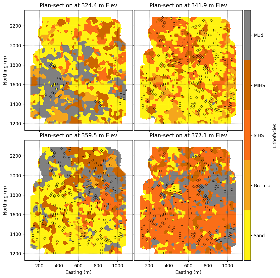
Example of category simulation: one of the realisations generated using the truncated hierarchical pluri-Gaussian simulation method (extracted from RMSP notebooks).
What’s next?
After thoroughly testing RMSP and developing specific workflows, we are now ready to take the next step — applying this knowledge to real projects. It is important to highlight that this tool does not replace our existing technologies; rather, it enhances and complements them, allowing us to work with greater efficiency and precision. Its integration with IsatisNeo, Leapfrog, Vulcan, Datamine, and GeoEstimaLib creates an ecosystem where each tool contributes its unique strengths.
Today, we are more prepared than ever to take on projects requiring advanced geostatistics — including those involving uncertainty, conditional simulations, or categorical variables — as well as any initiative demanding the highest technical and quality standards. Do you have complex challenges that require innovative geostatistical methodologies? We invite you to contact us and explore the opportunities this technological evolution allows us to deliver together.