Relevant Aspects to Consider During a Mineral Resource Model
Today, I want to introduce and discuss the basic concepts that should be understood when developing a Mineral Resource model.
Since this post will cover general topics, it's intended for an audience just starting out in this field, so you won’t find in-depth or complex information here. If you're looking to dig deeper, I’ve included links to articles on geostatisticslesson.com, a site I really like for exploring more technical aspects.
Let’s go step by step:
1. Database
Every Mineral Resource estimate starts with — and depends on — a reliable database. The information collected in the field, mainly through drilling, is the fundamental input for building geological models and estimating grades.
A typical database includes drillhole collar locations and downhole surveys (collars and downhole deviations), geological descriptions, assay results, densities, and quality control data (QA/QC). The integrity of this information must be validated before any modelling takes place. This involves checking coordinates and drill paths, reviewing sample duplicates, and ensuring the correct coding of lithologies or mineralised zones.
Implementing quality control routines—such as using standards, duplicates, and blanks—is essential to ensuring the reliability of analytical results. Likewise, a well-structured and secure database supports data traceability and allows for efficient updates as new results become available.
2. Deposit Geology
Understanding the deposit's geology is essential to connecting the collected data with the model to be built. Mineralisation follows patterns controlled by structures, lithologies, alterations, and geological processes that must be interpreted. For this reason, the geologist’s role can never be replaced—their professional experience and knowledge are key to ensuring the model’s geological consistency.
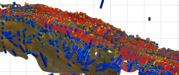
This combination of data and geological interpretation translates into three-dimensional models that represent the geometry of the mineralised body, the contacts between units, and the distribution of different geological domains. The modelled surfaces are useful for visualising the deposit, but they are also critical for defining estimation domains—that is, areas within which the grades are assumed to have similar statistical behaviour.
I recommend checking out the following content: https://geostatisticslessons.com/lessons/stationarity.
3. Statistics and Geostatistics
Before estimating grades, it’s necessary to understand how they are distributed and vary in space. Basic statistical analysis includes histograms, measures of central tendency and dispersion, and the identification of extreme values (outliers), which may need to be addressed to avoid overestimating the contained metal. Multivariate analysis is also required when there is more than one element of interest or significant correlations between variables.
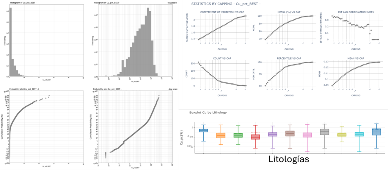
From a geostatistical perspective, analysing spatial continuity using variograms is essential. A variogram models how a grade value varies with distance and indicates the directions in which continuity is most substantial. This is a key step for selecting estimation parameters and, ultimately, for building a model that honours the actual spatial behaviour of the deposit.
For further information, I recommend visiting the following pages:
- https://geostatisticslessons.com/lessons/nuggeteffect
- https://geostatisticslessons.com/lessons/variogramanisotropy
- https://geostatisticslessons.com/lessons/variogramparameters
4. Grade Estimation and Conditional Simulations
We can move forward with grade estimation with a validated database, a clear geological interpretation, and a solid statistical analysis. This is typically done using kriging, inverse distance weighting (IDW), non-linear methods, or conditional simulations, applied to a block model that discretises the deposit into small volumetric units.
The choice of method depends on the study's objectives. Kriging, for instance, is useful when aiming for a single, unbiased estimate. At the same time, conditional simulations allow for modelling variability and quantifying uncertainty, which is especially important in early-stage evaluations or probabilistic mine planning.
This stage involves defining parameters such as block size, search radius, minimum and maximum number of samples, and adhering to the previously defined estimation domains. Grade estimation is done separately within each domain to avoid mixing populations with different statistical behaviours.
I recommend reviewing this content if you are interested in non-linear methods:
https://geostatisticslessons.com/lessons/localization
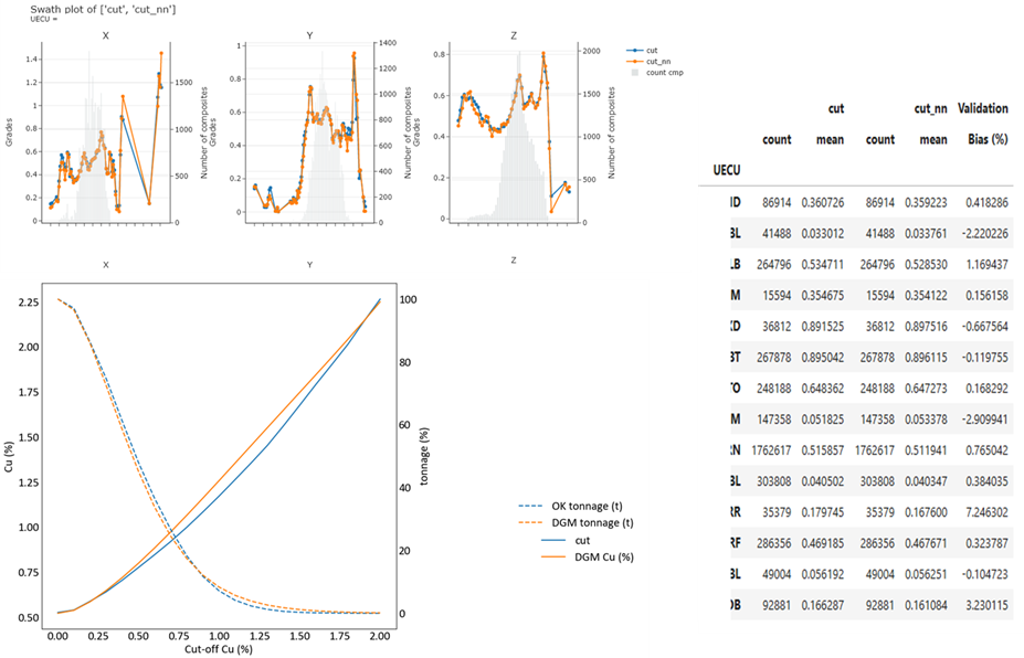
5. Model Validation
Once grades have been estimated, the model must be validated. This stage is crucial to ensure the results are consistent with the original data.
Validation involves statistical comparisons, visual checks on sections and plan views, and tools such as swath plots, which reveal spatial trends across the deposit.
Another important aspect is assessing the level of smoothing, as it may cause the model to underestimate high values and overestimate low ones. Depending on the model's intended use, this effect may be acceptable or may require adjustments—for example, by applying non-linear techniques such as Localised Uniform Conditioning (LUC) or by using simulations.
For more information, I recommend visiting:
https://geostatisticslessons.com/lessons/changeofsupport
6. Resource Classification
Once the model has been validated, the estimated resources must be classified according to the confidence level in the data, geology, and estimation. This classification is essential for supporting economic decisions and complying with international reporting standards such as JORC and NI 43-101.
Resources are categorised into three confidence levels:
- Measured
- Indicated
- Inferred
Classification is not based solely on data density — geological continuity and complexity, data quality, and the robustness of the model also play a critical role. Uncertainty analysis across different production volumes and drillhole spacings, often derived from conditional simulations, justifies each resource category.
7. Integrated Models and Uncertainty Management
The traditional approach of deterministically modelling geology and estimating grades through kriging has been instrumental in developing the mining industry. However, this approach has significant limitations when capturing mineral deposits' inherent variability and uncertainty.
Today, the industry has the opportunity to shift towards stochastic and integrated modelling, where grades, geology, metallurgical parameters, and geotechnical properties are simulated in multiple possible realisations. This approach does not aim to predict a single outcome but to understand the range of possible realities, quantify risk, and support more robust decision-making.
By working with multiple realisations instead of a single smoothed model, uncertainty can be integrated into mine planning, mine design, and economic evaluation.
Finally, I want to emphasise that progressing towards this new modelling approach requires tools, specialised knowledge, and an open mindset. But it is undoubtedly the necessary path to address the growing technical and economic complexity the mining industry faces.