
Categorical Simulation: HTPG and Its Ability to Express Geological Contacts
In a previous blog post, we gave a general overview of what conditional simulations are and how they make it possible to quantify the uncertainty of a resource model. We saw that this uncertainty can be integrated at different stages of the workflow, and one of the most relevant (and often least addressed) is geological uncertainty.
Geology has an intrinsic variability that directly affects mineralized volumes and reported tonnage. This uncertainty is also closely tied to the amount of information available: the fewer drillholes that define a contact, the greater the variability between the possible versions of that contact. Quantifying this variability, rather than working with a single deterministic geological model, makes it possible to identify areas that need more information and to size the geological uncertainty of the deposit.
A hierarchical tree to represent complex contacts
One of the most widely used families of methods for this purpose is truncated plurigaussian simulation (TPGS), which represents each category as a region defined by truncating one or more latent Gaussian variables (Matheron et al., 1987; Armstrong et al., 2011). A latent variable is essentially an auxiliary variable with no physical meaning of its own, acting as a mathematical representation of the category. It can be interpreted as how “close or far” a point in space is from a threshold that defines a contact: the farther from the threshold, the more consolidated the category is at that point; the closer, the higher the probability of being near a boundary between domains.
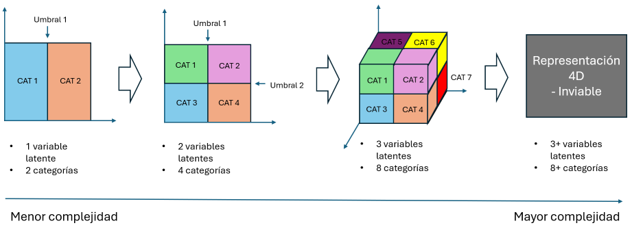
The problem is that this approach becomes impractical when the geology has more than three categories or complex contact relationships: the truncation mask grows in dimensions and becomes impossible to visualize or interpret geologically (see Figure 1), losing the clear connection between each region and the actual contact it is supposed to represent (Armstrong et al., 2011; Sektnan et al., 2025).
Hierarchical Truncated Plurigaussian Simulation (HTPG) overcomes this limitation by replacing the single mask with a hierarchical tree structure (Silva, 2018). Each (non-terminal) node of the tree represents a latent Gaussian variable and applies a truncation threshold; each leaf corresponds to a final geological category. This tree logic had already been proposed by Madani & Emery (2015) using a binary structure, but HTPG generalizes it by allowing each node to branch into more than two categories when the geology requires it. Unlike the classical mask, which requires observing all the latent variables at once, in HTPG the variables are applied sequentially and hierarchically: a first variable can separate large groups of categories, and subsequent ones subdivide each group until the final categories are reached (see Figure 2), simplifying the process even as the number of categories and latent variables grows. This makes it possible to build contact rules as complex as needed while keeping a clear geological meaning at each node: separating an eroded domain from an older one, isolating a discordant structure such as a dyke, or ordering a sequence of layers. This tree logic is what allows HTPG to intuitively express how a geologist reconstructs and interprets the contact relationships of a site of interest.
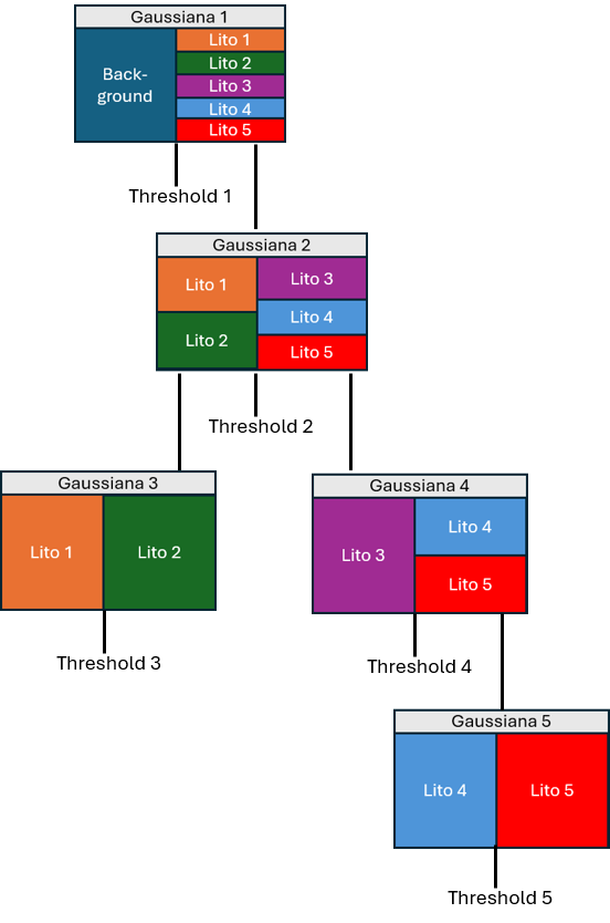
Defining the structure of the tree (which variable separates which categories, and in what order) solves the geometric part of the problem, but it is not enough on its own: each node also requires a specific threshold on the corresponding Gaussian variable. That threshold is not fixed: it is calculated directly from the proportion of each category, so that if the expected proportion varies from one zone of the deposit to another, the threshold is recalculated at each point to remain consistent with that local proportion.
Addressing non-stationarity: local proportions
In practice, the proportion of each category usually varies from one sector of the deposit to another, so truncation thresholds cannot be fixed across the entire domain: they must vary spatially, following the local proportions of each category. There are two common approaches to obtaining them:
- From a deterministic geological model: a Gaussian filter is applied to the block grid already coded with the deterministic geological model, smoothing the contacts and producing a gradual transition between domains, as shown in Figure 3. This is the natural option when a reliable reference geological model is already available.
- Calculated from the data: proportions are estimated directly from the composites using a moving average, seeking to minimize the correlation between the trend and the residuals. This is the appropriate alternative when there is no prior deterministic model from which to extract the trend, as can happen when subdividing domains into high-grade and low-grade subpopulations.
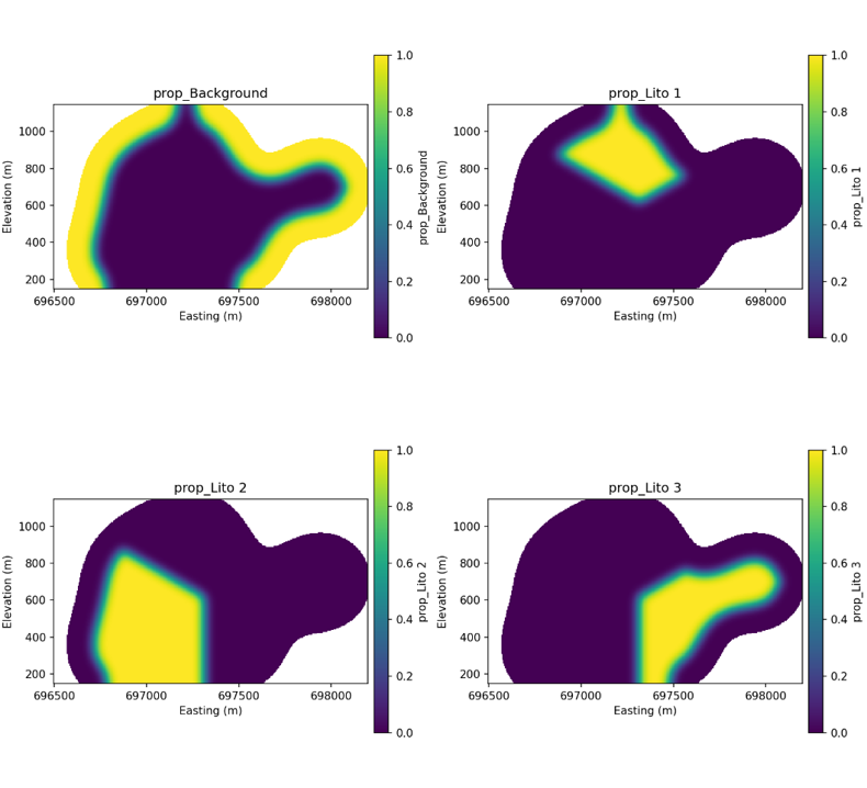
The two approaches are not mutually exclusive: at GeoEstima, we have used local proportions from the deterministic model to simulate the main geological domains, and proportions from the data to refine internal subdomains that have no geological model of their own.
A typical workflow
In a recent case at GeoEstima, HTPG was applied in two stages: first to simulate the main mineral zones, and then to subdivide each of them into high-grade and low-grade subdomains. In both cases, the workflow followed the same sequence:
- Generation of composites at regular support.
- Definition of local proportions (trends).
- Calculation of residuals and their variograms.
- Definition of the truncation rule (hierarchical tree).
- Derivation of the variogram of the latent variable(s).
- Imputation of the latent variable at the data locations.
- Simulation of the latent variable on the full grid.
- Truncation to obtain the categorical realizations.
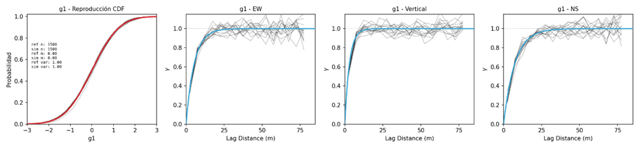
- Validation: reproduction of global proportions and indicator variograms.
This last point is key: it is not enough to generate realizations; we must verify that they reproduce both the proportion of each category and its spatial continuity before using them in the subsequent stages of the model (grade simulation, entropy calculation, resource classification). Figure 4 shows some typical validations.
This workflow is not specific to any one deposit: the same methodology can be applied to different projects and deposit types, adjusting the definition of the truncation tree and the source of the local proportions according to the information available in each case.
In summary
HTPG does not replace geological judgment: it translates it into a tree structure that can grow in complexity without losing interpretability. It is the combination of explicit contact relationships with well-defined local proportions that produces categorical models that look and behave like the geology they aim to represent.
Interested in how we could apply HTPG to your geological domains? Let’s talk.
This article provides a general summary of the concepts behind HTPG. Those looking for the full technical development, including the mathematical derivation of the thresholds, the latent variable imputation algorithm, or the methods for conditioning to the data, can visit https://geostatisticslessons.com, where various authors publish on this and other geostatistics topics.
References
- Armstrong, M., Galli, A., Beucher, H., Loc'h, G., Renard, D., Doligez, B., et al. (2011). Plurigaussian simulations in geosciences (2nd ed.). Springer-Verlag Berlin Heidelberg.
- Madani, N., & Emery, X. (2015). Simulation of geo-domains accounting for chronology and contact relationships: Application to the Río Blanco copper deposit. Stochastic Environmental Research and Risk Assessment, 29(8), 2173–2191.
- Matheron, G., Beucher, H., De Fouquet, C., Galli, A., Guerillot, D., & Ravenne, C. (1987). Conditional simulation of the geometry of fluvio-deltaic reservoirs. In SPE Annual Technical Conference and Exhibition. Society of Petroleum Engineers.
- Sektnan, A., Almendral Vázquez, A., Hauge, R., Aarnes, I., Skauvold, J., & Vevle, M. L. (2025). A Tree Representation of Pluri-Gaussian Truncation Rules. Mathematical Geosciences, 57, 445–470.
- Silva, D. (2018). Enhanced geologic modeling of multiple categorical variables (Doctoral dissertation, University of Alberta).
- Silva, D., & Deutsch, C. V. (2026). Categorical Simulation by Truncating Gaussian Random Fields. In J. L. Deutsch (Ed.), Geostatistics Lessons. Retrieved from http://www.geostatisticslessons.com/lessons/htpgtheory